District Info
School Board
Departments
Educational Services
Parents/Students
Community Resources
Firearms Safety
Health Information
Staff Info
Click to view full PDF document
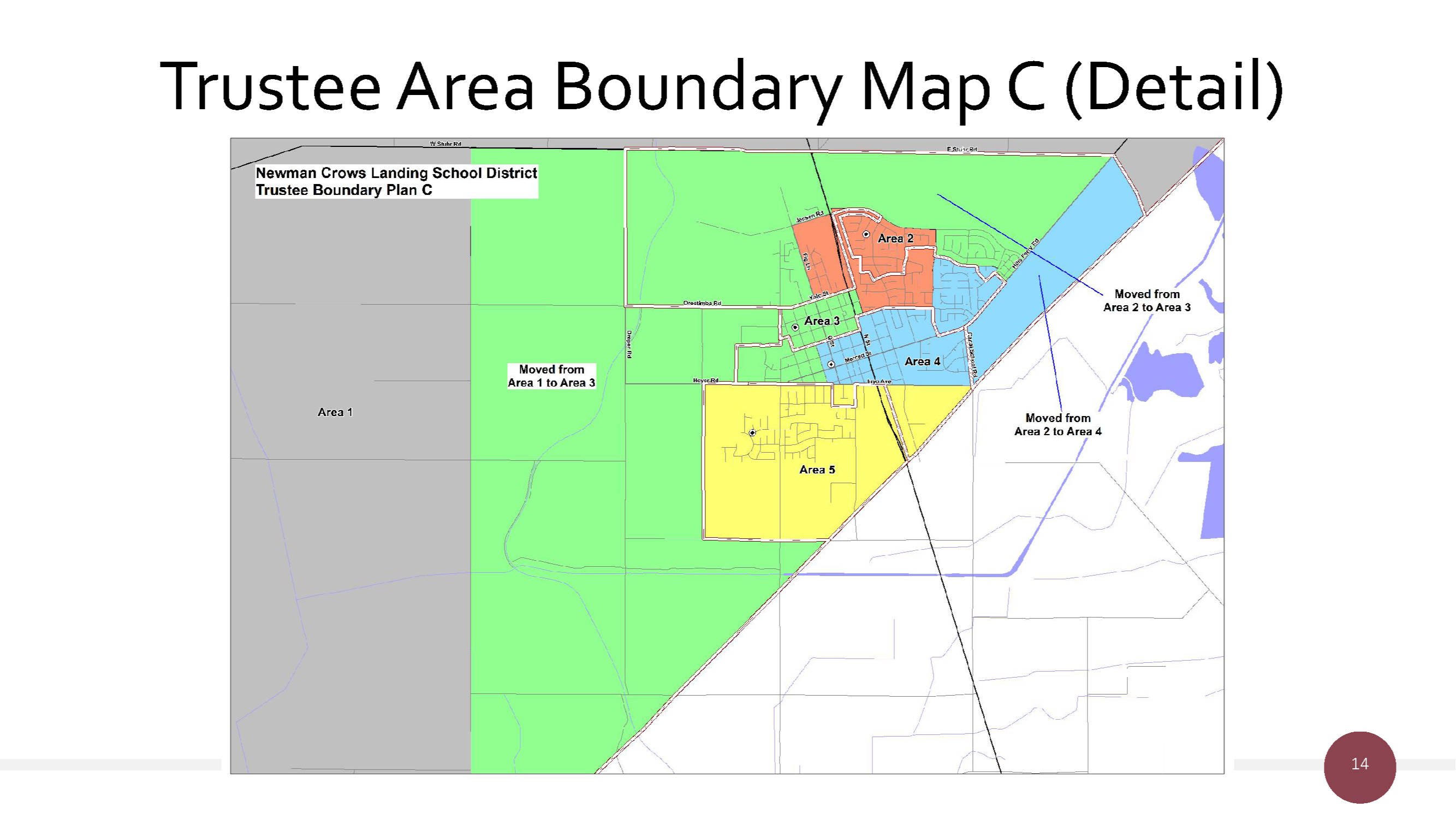
Trustee Area 1:
Beginning at the intersection of the District’s eastern border and the private dirt road on the southwestern border of parcel APN 049043009000; then proceeding northwest along the dirt road to the intersection of the dirt road, Hills Ferry Rd, and E Stuhr Rd; then proceeding westerly along E Stuhr Rd and W Stuhr Rd to Eastin Rd; then proceeding southerly along Eastin Rd to the District border; then proceeding clockwise along the District border to the point of beginning.
Trustee Area 2:
Beginning at the intersection of Barrington Ave and Sherman Parkway; then proceeding southerly along Barrington Ave to Driskell Ave; then proceeding westerly along Driskell Ave to the Southern Pacific Railroad; then proceeding northerly along Southern Pacific Railroad to the extension of Yolo St; then proceeding westerly along Yolo St to Fig Ln; then proceeding northerly along Fig Ln to Jensen Rd; then proceeding easterly along Jensen Rd to the Southern Pacific Railroad; then proceeding northerly along Southern Pacific Railroad to the northern border of parcel APN 026060038000; then proceeding east along the northern board of parcel APN 026060038000 and continuing easterly along Sherman Parkway to the point of beginning.
Trustee Area 3:
Beginning at the intersection of the District’s eastern border and Hallowell Rd; then proceeding westerly along Hallowell Rd to Harvey Rd; then proceeding northerly along Harvey Rd to Hoyer Rd; then proceeding easterly along Hoyer Rd and Inyo Ave to R St; then proceeding northerly along R St to Tulare St; then proceeding easterly along Tulare St to N St (State Highway 33); then proceeding northerly along N St to Driskell Ave; then proceeding easterly along Driskell Ave to the Southern Pacific Railroad; then proceeding northerly along Southern Pacific Railroad to the extension of Yolo St; then proceeding westerly along Yolo St to Fig Ln; then proceeding northerly along Fig Ln to Jensen Rd; then proceeding easterly along Jensen Rd to the Southern Pacific Railroad; then proceeding northerly along Southern Pacific Railroad to the northern border of parcel APN 026060038000; then proceeding east along the northern board of parcel APN 026060038000 and continuing easterly along Sherman Parkway to Barrington Ave; then proceeding southerly along Barrington Ave to Red Lion Way; then proceeding easterly along Red Lion Way to Cinnamon Teal Way; then proceeding southwesterly along Cinnamon Teal Way to Edinburgh Way; then proceeding southeasterly along Edinburgh Way to Hills Ferry Rd; then proceeding northeasterly along Hills Ferry Rd to E Stuhr Rd; then proceeding westerly along E Stuhr Rd and W Stuhr Rd to Eastin Rd; then proceeding southerly along Eastin Rd to the District border; then proceeding counter-clockwise along the District border to the point of beginning.
Trustee Area 4:
Beginning at the intersection of the District’s eastern border and the private dirt road on the southwestern border of parcel APN 049043009000; then proceeding northwest along the dirt road to the intersection of the dirt road, Hills Ferry Rd, and E Stuhr Rd; then proceeding southwesterly along Hills Ferry Rd to Edinburgh Way; then proceeding northwesterly along Edinburgh Way to Cinnamon Teal Way; then proceeding northeasterly along Cinnamon Teal Way to Red Lion Way; then proceeding westerly along Red Lion Way to Barrington Ave; then proceeding southerly along Barrington Ave to Driskell Ave; then proceeding westerly along Driskell Ave to N St (also known as State Highway 33); then proceeding southerly on N St to Tulare St; then proceeding westerly along Tulare St to R St; then
proceeding southerly along R St to Inyo Ave; then proceeding easterly along Inyo Ave to Canal School Rd; then proceeding southerly along Canal School Rd to the District border; then proceeding counter-clockwise along the District border to the point of beginning.
Trustee Area 5:
Beginning at the intersection of the District’s eastern border and Hallowell Rd; then proceeding westerly along Hallowell Rd to Harvey Rd; then proceeding northerly along Harvey Rd to Hoyer Rd; then proceeding easterly along Hoyer Rd and Inyo Ave to Canal School Rd; then proceeding southerly along Canal School Rd to the District border; then proceeding clockwise along the District border to the point of beginning.